Build the Surveying Education for Your Next Professional Step
Advance your surveying career with the online Post-Baccalaureate Certificate in Geomatics at Texas A&M University-Corpus Christi. Designed for individuals who already hold a bachelor's or master's degree in another field, this focused 33-credit certificate provides surveying and geomatics coursework that can support a pathway toward Surveyor-in-Training certification and eventual professional licensure in Texas.
Program Details
The Post-Baccalaureate Certificate in Geomatics provides specialized surveying education for professionals who already hold a bachelor's or master's degree in a field other than geomatics or geographic information science.
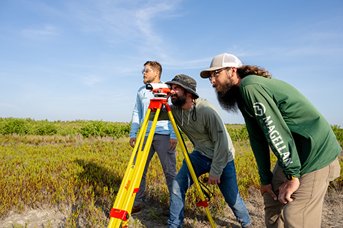 Students complete coursework in plane measurement, boundary surveying, land law, geodetic science, satellite positioning, cadastral systems, digital drafting, geospatial systems, and surveying computations and adjustment. The curriculum develops the measurement, analytical, legal, and technical knowledge used in modern land surveying practice.
The certificate requires 33 credit hours, including at least 20 credit hours completed at Texas A&M University-Corpus Christi. Each student completes a Certificate Plan approved by the Geospatial Science Program Coordinator or a designee. Appropriate surveying coursework completed previously may be considered when developing that plan.
What You’ll Learn
Through the certificate, students develop the ability to:
- Measure, collect, and evaluate geospatially referenced data
- Perform plane surveying measurements and computations
- Apply geodetic and satellite-positioning methods
- Interpret deeds, records, plats, and other boundary evidence
- Understand cadastral systems and land ownership frameworks
- Apply legal and ethical principles to surveying practice
- Complete surveying computations and adjustment procedures
- Prepare survey maps, designs, reports, and field instructions
- Integrate surveying information from multiple sources
- Use digital drafting, GIS, and other geospatial technologies
Advance Your Surveying Expertise
The certificate may be a strong fit for:
- Surveying professionals who already hold a bachelor's or master's degree
- Individuals working under the supervision of a Registered Professional Land Surveyor
- Engineers, GIS professionals, and other geospatial specialists seeking formal surveying education
- Degree-holding professionals preparing for the Fundamentals of Surveying exam
- Professionals seeking deeper knowledge of boundary surveying, geodesy, GNSS, land law, and cadastral systems
Pathway toward Professional Licensure
Surveyor-in-Training certification is the beginning point in the Texas professional land surveyor licensure process. The Post-Baccalaureate Certificate in Geomatics provides surveying education that may be applied toward the educational component of SIT eligibility.
The Texas Board of Professional Engineers and Land Surveyors provides five combinations of education and experience through which an applicant may qualify. For an individual who already holds a bachelor's degree, one qualifying route includes 32 semester hours in board-accepted subject areas and one year of qualifying delegated responsible charge experience in boundary surveying or boundary determination under an RPLS.
When you are ready, reach out.
Have questions? We're here to help. Whether you're exploring the program or ready to apply, our faculty is happy to guide you every step of the way.

Visit Us
If you'd like to see more of TAMU-CC, enjoy our immersive 360° virtual tour or schedule an in-person visit.